
Cruise port
Cruises from Petropavlovsk
Petropavlovsk-Kamchatsky lies on the natural harbor of Avacha Bay. Discover the city’s history, its port location, and Kamchatka’s volcanic landscape.
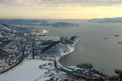
Photo: (public licese) commons.wikimedia.org
Petropavlovsk-Kamchatsky lies on Avacha Bay on the eastern coast of the Kamchatka Peninsula. The bay forms the city’s natural harbor and opens onto the North Pacific. The city’s geographic setting is defined by its volcanic landscape and coastline.
A Port City on Avacha Bay
The city’s history is linked to the Second Kamchatka Expedition. In October 1740, the packet boats “Svyatoy Pyotr” and “Svyatoy Pavel,” led by Vitus Bering and Alexei Chirikov, entered the bay. Bering named the settlement Petropavlovskaya Gavan, meaning Peter and Paul Harbor. October 17 is regarded as the founding date of the present-day city. The bay’s location was also important for maritime exploration and supplying Russia’s Far East.
The shape of the bay’s coastline provides a sheltered natural harbor. The seaport connects Petropavlovsk-Kamchatsky with shipping routes across the North Pacific. Port operations, supplies, and passenger traffic depend on the facilities available and specific schedules.
The Kamchatka Peninsula is characterized by volcanoes and coastline.
City and Volcanic Landscape
The city stretches along the Pacific coast. Its prominent landmarks include Avacha Bay and the peninsula’s volcanoes. The city’s history spans from the expeditions of the 18th century to its later role as a regional center. The Bering expedition and the naming of the settlement explain why the two packet boats are still remembered as part of local history.
For cruise travelers, Petropavlovsk-Kamchatsky is therefore best understood as a port on Avacha Bay and a gateway to the volcanic Kamchatka Peninsula. Specific port calls, embarkation points, and transport connections depend on the itinerary.

